
- Table of Contents
- Foreword
- Introduction
- Texas Waterway Map
- Map Key
- East Texas Waterways
- Central Texas Waterways
- Major Waterways:
- Blanco River
- Bosque River
- Brazos River
- Colorado River
- Concho River
- Frio River
- Guadalupe River
- Lampasas River
- Lavaca River
- Leon River
- Little River
- Llano River
- Medina River
- Navidad River
- Nueces River
- Paluxy River
- Pedernales River
- San Antonio River
- San Bernard River
- San Gabriel River
- San Marcos River
- San Saba River
- Wichita River
- Seasonal and Restrictive Waterways
- Major Waterways:
- West Texas Waterways
An Analysis of Texas Waterways
A Report on the Physical Characteristics of Rivers, Streams, and Bayous in Texas
Major Waterways of Central Texas
Llano River
The Llano River is formed in Kimble County by the union of the North and South Llano Rivers. The main stream flows east through Kimble, Mason, and Llano Counties for approximately 100 miles where it joins the Colorado River and aids in forming Lake Lyndon B. Johnson. The Llano is a spring-fed stream of the Edwards Plateau and is widely known for its scenic beauty. The river from Junction to Lake LBJ best accommodates recreational use when the river is on a slight rise. Many challenging rapids are formed at high water levels. When the water level is normal or below normal, several shallow areas hinder recreational use.
North Fork
(Not mapped)
Sutton and Kimble Counties
The North Llano River rises in central Sutton County and flows eastward to join the South Llano River at Junction, forming the main stream. The North Llano is 40 miles long and flows through an area of scenic limestone bluffs and hills. The North Fork contains a limited water flow during normal conditions averaging approximately 40 cubic feet per second (CFS). In Sutton County the river is 20 to 50 feet wide, and is interspersed with many shallow areas. The section in Kimble County consists of quiet pools and some small rapids. Recreational use of the North Llano River is feasible only during periods of heavy run-off. The following waterway features on the North Fork were found.
County road crossing off US 290 - 6 miles west of Roosevelt.
Camp Allison County Park - off US 290 on the dirt river road.
A camping area is available.
County road crossing off Spur 291 - 1 mile west of Roosevelt.
County road crossing off Spur 291 - in town of Roosevelt.
US 290 crossing - 3 miles east of Roosevelt.
County road crossing off US 290 - 12 miles west of Junction.
County road crossing off US 290 - 1 mile west of Junction.
US 290 crossing - 7 miles west of Junction.
County road crossing off US 290 - 5 miles west of Junction.
US 290 crossing - 4 miles west of Junction.
US 290 and US 83 crossing - northern city limit of Junction.
South Fork
(Not mapped)
Edwards and Kimble Counties
The South Llano River, formed in Edwards County, flows 55 miles northeast into Kimble County. The South Llano joins the North Llano at Junction to form the main stream. The South Llano is a scenic, spring-fed stream flowing through the Hill County of South Central Texas. Because of the springs, the South Llano has a healthy flow of water at all times, averaging in the vicinity of 75 cubic feet per second (CFS). However, some shallow places are generally found at normal water levels. The best conditions for recreational use of the waterway occur when rain is abundant and the river is on a slight rise. One of the most scenic and popular sections of the South Llano is located near Telegraph, Texas. This area is widely known for the "700 springs" which pour out of high limestone bluffs. The river in this vicinity contains short riffles, chutes, small rapids, and still pools of water. Water levels are adequate for recreational use in this area, but the flow is reduced within 5 or 6 miles of Telegraph.
The South Llano has exceptional potential for recreational use when water levels are sufficient. Waterway features are as follows:
US 377 crossing - 9 miles northeast of Rocksprings.
County road crossing off US 377 - 14 miles southwest of Junction.
County road crossing off US 377 - 13 miles southwest of Junction.
US 377 crossing - 12 miles southwest of Junction.
Private camp off US 377 - 12 miles southwest of Junction.
US 377 crossing - 11 miles southwest of Junction.
Private camp off US 377 - 10 miles southwest
of Junction.
Private camp off US 377 - 9.5 miles southwest
of Junction.
Private camp off US 377 - 4 miles southwest
of Junction.
Private camp off US 377 - 1 mile south of
the high bridge in Junction.
Junction City Park on Junction City Lake in
Junction. Good access is available.
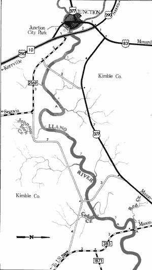
Llano River
Junction to Farm-to-Market 385
19 Miles
Junction to Farm-to-Market 385
19 miles
This 19-mile section of the Llano River in Kimble County has some potential for recreational use. The river on this section moves slowly, and no major rapids are present. The banks slope gently to the river and the flood plain is wide and flat, revealing typical ranch lands of the Texas Hill Country. Occasionally a small outcropping of limestone or similar rock formations are found. Vegetation along this section consists of ranchland-associated plants, such as yucca, cacti, mesquite, cedar, and live oak. These plants are especially noticeable whenever the flood plain widens. However, hardwood bottomlands containing elm, willow, sycamore, and salt cedar are also present. In places where there is little current, hydrophytic plant such as water lilies and oleander are found.
Water quality is fair along most portions of this section. Water levels on this section are sufficient for recreational use at most times with no potential hazards or large rapids. Waterway features and distance between each are as follows:
Junction City Lake - located on the South
Llano in the city of Junction. A small
dam creates a lake on the river. A city
park provides access on the south side
of the river below the dam.
North Llano River - enters on the left.
(0.3 mile)
IH 10 crossing - 1 mile east of Junction.
The river is completely fenced off on
all four sides. (0.2 mile)
County road crossing - 2 miles east of
Junction between US 377 and FM 2169.
Access is very poor. (3 miles)
Private camp - located 4 miles east of
Junction off FM 2169. Approximately
2 miles of shoreline are available. Picnicking and camping facilities are
provided. (3 miles)
Johnson Fork Creek-enters on the right.
(1 mile)
County road crossing - off US 377, 11 miles
east of Junction. (7 miles)
Cedar Creek - enters on the right. (1 mile)
Private camp - 20 miles northeast of
Junction, off US 377. (2 miles)
Red Creek - enters on the left. (1 mile)
FM 385 crossing - 20 miles northeast of
Junction. (0.5 mile)
Private camp - immediately downstream
from FM 385 crossing. Three miles of
shoreline are available, but no facilities
are provided. (0.1 mile)
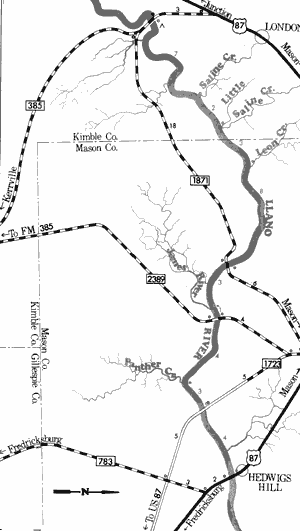
Llano River
Farm-to-Market 385 to US Highway 87
35 Miles
Farm-to-Market 385 to US Highway 87
35 miles
This 35-mile section of the Llano River in Kimble and Mason Counties has good potential for recreational use. The river is slow-moving with only a few minor rapids and areas of swift water. The outstanding scenic qualities of the river become more prominent as the river moves downstream. Here the Llano is fairly broad, shallow stream containing many areas which open out to reveal the ranchland setting of the Hill Country. Several cliffs composed of layers of reddish-brown sandstone rock rise 200 to 300 feet upward. Very picturesque, these cliffs are unique to this area.
Numerous stretches of calm, placid water exist along this section. These stretches are quite shallow at normal water levels. Water quality improves considerably as the river moves downstream. Occasional sand and gravel bars which often lend themselves to camping and day use exist. Vegetative types remain the same as in the previous section, consisting of elm, pecan, willow, and salt cedar along the banks; and mesquite, yucca, cacti, live oak, and cedar on the hills and adjacent ranchlands. Waterway features and distance between each are as follows:
35 Miles FM 385 crossing - 20 miles northeast of
Junction.
Private camp - immediately downstream
from FM 385 crossing. Three miles of
shoreline are available, but no facilities
are provided. (0.1 mile)
Saline Creek - enters on the left. (7 miles)
Little Saline Creek - enters on the left.
(2 miles)
Leon Creek - enters on the left. (3 miles)
FM 1871 crossing - 8 miles southwest of
Mason. (8 miles)
James River - enters on the right. (3 miles)
FM 2389 crossing - 5.5 miles south of Mason.
A large island provides a good area for
access, camping and day use. (1 mile)
Panther Creek - enters on the right. (4 miles)
County road crossing - off FM 1723, 7 miles
south of Mason. Access is very poor.
(3 miles)
US 87 crossing - 9 miles southeast of
Mason at Hedwig's Hill. (4 miles)
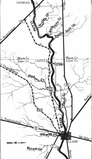
Llano River
US Highway 87 to Llano
30 Miles
US Highway 87 to Llano
30 miles
Located in Mason and Llano Counties, this 30-mile section of the Llano River is an extremely scenic section, yet recreational usage is difficult unless the river is on a rise. The riverbed becomes extremely wide (sometimes as wide as 100 yards). Normal water flow over this wide riverbed often results in the river being extremely shallow. Large boulders and slabs of granite and gneiss cause the river to split, and the river sometimes disperses in several directions. Few of the segmented streams have sufficient water for recreational use at normal water levels. However, when the river is on a 1 to 2 foot rise, excellent conditions exist for recreational usage. This section of the Llano is widely known for the one-billion year old igneous and metamorphic rocks which form the riverbed. This area is a part of the Llano Uplift which is one of the most unique geologic features in Texas. Typical Hill Country ranchland activities are seen from the river, along with river associated plants; such as elm, willow, sycamore, and plenty of salt-cedar. Many sand and gravel bars which often provide camping and day use areas exist.
Water quality along this section is good and access is no problem due to the existence of several road crossings. Waterway features and distance between each are as follows:
US 87 crossing - 9 miles southeast of
Mason at Hedwig's Hill.
Willow Creek - enters on the left. (3 miles)
Mulberry Creek - enters on the left. (3 miles)
Twelve Mile Creek - enters on the left.
(1 mile)
Private camp - 22 miles east of Mason off
FM 152. About 1 mile of shoreline is
available. (3 miles)
FM 2768 crossing - 16 miles west of Llano
near the Mason-Llano county line.
(2 miles)
County road crossing - off RR 152. 12 miles
west of Llano. (5 miles)
Hickory Creek - enters on the right.
(3.5 miles)
County road crossing - off RR 152, 8 miles
west of Llano. (0.5 mile)
San Fernando Creek - enters on the left.
(5 miles)
Pecan Creek - enters on the left. (3 miles)
Robinson City Park - off RR 152, in the
western edge of Llano. About 1 mile of
shoreline is available at this small
30-acre lake. Picnicking facilities are
available, but no camping is allowed.
(1 mile)
Small dam - a portage would be required.
SH 16 crossing - in the city of Llano. The
high bridge provides poor access.
Llano to Lake LBJ
(Not mapped)
20 miles
This section of the Llano River, from SH 16 to Lake Lyndon B. Johnson, is a 20-mile stretch very similar to the section immediately above it. The river is wide and many large boulders tend to cause the normal flow of the river to separate into several small streams. However, during periods of high water, there is a sufficient flow for recreational use, and many good rapids exist. The river is quite scenic, containing one billion year old gneiss and granite outcroppings along the banks and in the riverbed. There is only one road crossing on the section, that being 19 miles downstream from SH 16 crossing in Llano. Just below this county road crossing, slack water is formed by Lake LBJ.
Top of Page | Table of Contents