- Table of Contents
- Foreword
- Introduction
- Texas Waterway Map
- Map Key
- East Texas Waterways
- Central Texas Waterways
- Major Waterways:
- Blanco River
- Bosque River
- Brazos River
- Colorado River
- Concho River
- Frio River
- Guadalupe River
- Lampasas River
- Lavaca River
- Leon River
- Little River
- Llano River
- Medina River
- Navidad River
- Nueces River
- Paluxy River
- Pedernales River
- San Antonio River
- San Bernard River
- San Gabriel River
- San Marcos River
- San Saba River
- Wichita River
- Seasonal and Restrictive Waterways
- Major Waterways:
- West Texas Waterways
An Analysis of Texas Waterways
A Report on the Physical Characteristics of Rivers, Streams, and Bayous in Texas
Major Waterways of East Texas
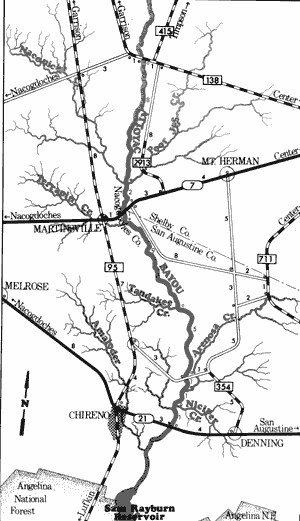
Attoyac Bayou
Farm-to-Market 138 to State Highway 21
28 Miles
Attoyac Bayou
Attoyac Bayou, formed in southeast Rusk County near the town of Mount Enterprise, flows approximately 58 miles southeast into the Angelina River and Sam Rayburn Reservoir. Forming the boundary between Nacogdoches, Shelby, and San Augustine Counties for much of its course, Attoyac Bayou flows through forested hardwood bottomlands, the majority of which are owned by large lumber companies. The lower section of the bayou has sufficient water for recreational activities almost year round; however, the upper section is extremely seasonal in nature. The entire length of the bayou is characterized by log jams which are often the major handicap to navigation.
Farm-to-Market 1971 to Farm-to-Market 138
(Not mapped)
19 miles
The upper reaches of Attoyac Bayou in Nacogdoches and Shelby Counties flow through scenic hardwood bottomlands. Along this stretch, the bayou is very shallow and contains numerous log jams. During periods of heavy rainfall, this section has potential for recreational activities, but under normal conditions does not contain sufficient water to permit extensive use. Along the lower section of Attoyac Bayou, recreational usage is feasible except during periods of extremely low water.
Attoyac Bayou
Farm-to-Market 138 to State Highway 21
28 miles
This section of Attoyac Bayou is lined with heavy vegetation. Here, the bayou is approximately 50 feet wide and has a healthy flow of water in all but very dry periods. Occasionally, log or brush jams are found; however, recreational usage is generally feasible along this stretch.
Recreational usage of this section of Attoyac Bayou often begins at the FM 138 crossing (4 miles east of FM 95 and 10 miles southeast of Garrison). Reports indicate that there are approximately 1300 feet of shoreline available on the highway right-of-way. Waterway features and the distance between each are as follows:
Naconiche Creek on the right and Poor
Joe Creek on the left (8 miles)
SH 7 crossing - 1 mile east of Martinsville.
(2 miles)
Terrapin Creek - on the right. (1 mile)
Tandakee Creek - on the right. (9 miles)
County road crossing off FM 354 - 6 miles
northwest of Denning. Reports indicate
that approximately 500 feet of highway
right-of-way and a boat ramp are
available at this site. (5 miles)
Arenosa Creek - on the left. (1 mile)
Niciper Creek - on the left. (1 mile)
SH 21 crossing - 3 miles east of Chireno.
Approximately 500 feet of shoreline are
reportedly available on the highway right-of-way. (1 mile)
Attoyac Bayou runs into Sam Rayburn Reservoir eight miles downstream. Camping and picnic facilities are maintained by the U.S. Army Corps of Engineers at various parks located on the reservoir. These parks are often utilized as alternate access points by recreationists.
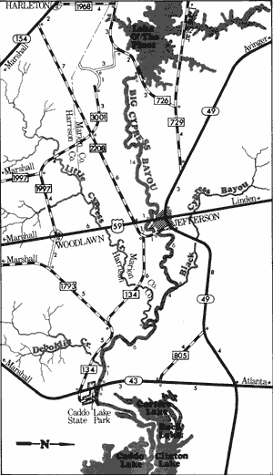
Big Cypress Bayou
Lake O' The Pines to Caddo Lake State Park
34 Miles
Big Cypress Bayou
Big Cypress Bayou (sometimes called Big Cypress Creek) is formed in the southern part of Franklin County and flows eastward into Camp, Titus, Morris, Marion, and Harrison Counties. Two major water impoundments, Lake O' The Pines and Caddo Lake, are located on the Bayou. Lake Franklin County, a small impoundment, is located at the headwaters of the bayou. Big Cypress Bayou flows for approximately 38 miles in its upper reaches and an additional 34 miles between Lake O' The Pines and Caddo Lake. Running its entire course through a heavily forested region of northeast Texas, these upper reaches of the bayou are subject to varying water conditions and are not always suitable for recreational use. Log jams are prevalent when floating Big Cypress Bayou and may hinder navigation.
Lake Franklin County Dam to Lake O' The Pines
(Not mapped)
38 miles
Big Cypress Bayou (sometimes called Big Cypress Creek), in its upper reaches, flows through a heavily vegetated section of East Texas. Virgin hardwoods and a wide variety of wildlife are common along these 38 miles above Lake O' The Pines. Here, water conditions are not normally adequate for recreational activities; however, during periods of run-off, it is possible to float portions of the upper reaches. Often, many hazardous log and brush jams are found which impair navigation. The best sections for recreational use of the upper reaches are: 1) The 29-mile section between FM 21 crossing (11 miles southwest of Mt. Pleasant) and US 271 crossing (5 miles north of Pittsburg). 2) the 8-mile section between US 271 crossing and the SH 11 crossing (5 miles northeast of Pittsburg). 3) the 15-mile section between SH 11 crossing and US 259 crossing ( 8 miles south of Daingerfield).
A few miles downstream from the above mentioned section, Big Cypress Bayou flows into Lake O' The Pines. Here camping and picnic facilities are maintained by the U.S. Army Corps of Engineers and these parks are often utilized by waterway recreationists.
Lake O' the Pines to Caddo Lake State Park
34 miles
This 34-mile section of Big Cypress Bayou, one of the more popular waterways in Texas, is contained wholly within Marion County. This section flows through a jungle-like bottomland where cypress trees are a common element. Here, there is always adequate water for recreational usage for at least the lower half of this section. The upper portion (from Lake O' The Pines to Jefferson) however is only suitable for recreational activities when sufficient water is being released from Ferrell's Bridge Dam. The normal release from the dam is five (5) cubic feet per second (CFS), which results in an inadequate flow for recreational use from the dam to Jefferson. However, during flood periods, particularly during the spring, fall, and winter, the dam often generates up to 1000 CFS, which results in excellent water levels for recreational activities. The summer months normally have low flows and restrict most recreational use. The section from the dam to Jefferson is relatively narrow and the many log jams encountered can be hazardous to navigation. However, the bayou becomes wide and deep from Jefferson to Caddo Lake, and even large motorized boats are used.
Recreational activities along this section of Big Cypress Bayou are feasible from the dirt road off of FM 726 below Ferrell's Bridge Dam to Caddo Lake State Park. As reported, approximately one-fourth mile of shoreline at FM 726 is maintained by the U.S. Army corps of Engineers and is often utilized for access by recreationists. Additional waterway features and the distance between each are as follows:
US 59 crossing - 1 mile south of Jefferson
(14 miles)
FM 134 crossing - in Jefferson. TPWD boat ramp is available for use. (2 miles)
Black Cypress Bayou - enters on the left.
(6 miles)
Little Cypress Bayou - enters on the right.
(4 miles)
Deboldin Creek - enters on the right.
(6 miles)
SH 43 crossing - 10 miles southwest of Jefferson.
TPWD boat ramp is available for use. (1 mile)
Caddo Lake State Park - camping and picnic facilities are available in the park. (1 mile)
Top of Page | Table of Contents