- Table of Contents
- Foreword
- Introduction
- Texas Waterway Map
- Map Key
- East Texas Waterways
- Central Texas Waterways
- Major Waterways:
- Blanco River
- Bosque River
- Brazos River
- Colorado River
- Concho River
- Frio River
- Guadalupe River
- Lampasas River
- Lavaca River
- Leon River
- Little River
- Llano River
- Medina River
- Navidad River
- Nueces River
- Paluxy River
- Pedernales River
- San Antonio River
- San Bernard River
- San Gabriel River
- San Marcos River
- San Saba River
- Wichita River
- Seasonal and Restrictive Waterways
- Major Waterways:
- West Texas Waterways
An Analysis of Texas Waterways
A Report on the Physical Characteristics of Rivers, Streams, and Bayous in Texas
Major Waterways of Central Texas
San Gabriel River
The San Gabriel River is formed at Georgetown by the union of its North and the South Forks. After the forks unite, the river flows northeast about 50 miles through Williamson and Milam Counties where it joins the Little River. The scenery along the main stream of the San Gabriel is varied, with heavy vegetation on the banks and periodic bluffs. Water levels fluctuate for the entire length of the river; however, except during the dry summer periods, there is normally sufficient water for recreational use.
North Fork
(Not mapped)
43 miles
The North San Gabriel River is formed in Burnet County and flows generally southward through Burnet and Williamson Counties to join the South Fork in Georgetown. The waterway is scenic, winding river flowing through limestone formations typical of the Edwards Plateau. Recreational usage is restricted to periods of abundant rainfall since the river usually does not have a steady flow. Waterway features are as follows:
County road crossing off FM 2340 - 8 miles northeast of Burnet.
FM 963 crossing - 8 miles northeast of Burnet.
FM 1174 crossing - 7 miles northwest of Burnet.
County road crossing off FM 243 - 6 miles north of Bertram.
FM 243 crossing - 7 miles northeast of Bertram.
County road crossing off US 183 - 8 miles north of Liberty Hill.
County road crossing off US 183 - 5 miles north of Liberty Hill.
County road crossing off US 183 - 3 miles northwest of Liberty Hill.
US 183 crossing - 3 miles northeast of Liberty Hill.
County road crossing off US 183 - 4 miles northeast of Liberty Hill.
County road crossing off US 183 - 5 miles northeast of Liberty Hill.
County road crossing off US 183 - 6 miles northeast of Liberty Hill.
County road crossing off FM 2338 - 4 miles west of Georgetown.
County road crossing off FM 2338 - 3 miles west of Georgetown.
Interstate Highway 35 crossing in Georgetown.
South Fork
(Not mapped)
34 miles
Formed in Burnet County, the South San Gabriel River flows generally eastward through Williamson County to eventually join the North San Gabriel River at Georgetown. The two forks are quite similar. The total length of the river is approximately 34 miles. The South San Gabriel River is a scenic, winding river containing numerous limestone bluffs. However, recreational usage is restricted to periods of sufficient rainfall since the South Fork does not normally maintain a steady flow. Waterway features are as follows:
FM 243 crossing - 3 miles southwest of Bertram.
FM 1174 crossing - 2 miles south of Bertram.
County road crossing off FM 1174 - 3 miles south of Bertram.
FM 1869 crossing - 1 mile west of Liberty Hill.
County road crossing - 1 mile south of Liberty Hill.
US 183 crossing - 3 miles north of Leander.
County road crossing - 3 miles north of Leander.
County road crossing off SH 29 - 11 miles west of Georgetown.
IH 35 crossing - west city limits of Georgetown.
Small lake in Georgetown at the City Park.

San Gabriel River
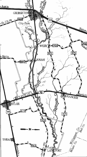
Georgetown City Park to Laneport
37.5 Miles
Georgetown City Park to Laneport
37.5 miles
This 37.5-mile section of the San Gabriel River is contained entirely within the boundaries of Williamson County. The width of the river varies from 20 to 40 feet with the water level being rather shallow, especially during dry summer months. However, a minimum flow for recreational use almost always is available. The scenery along this section of the river is varied, since some stretches are grasslands, some cliffs and bluffs, and others having vegetation so thick that it overhangs the water. A wide variety of birds and some beaver are found on this area along with some small rapids.
No large dams or reservoirs are located along this stretch and low water crossings provide adequate access. Overall, this section is a good recreational waterway and is ideal for inexperienced recreationists. A good entry point for use of this section of the San Gabriel River is Georgetown City Park. The park offers access to about one-half mile of shoreline and restrooms and picnic tables are available. Additional waterway features and distance between each are as follows:
Berry Creek - enters on the left.
SH 29 crossing - 4 miles east of Georgetown,
250 feet if shoreline are available. (7 miles)
County road crossing off SH 29 - 4 miles east
of Georgetown.
Manske Branch - enters on the right.
FM 1660 crossing - 1 mile south of SH 29.
(3 miles)
County road crossing off SH 29 - 2 miles
east of Circleville. (5 miles)
SH 95 crossing - in town of Circleville.
(3 miles)
Pecan Branch - enters on the left.
County road crossing off FM 1331 - 4 miles
west of Circleville. (7 miles)
Opossum Creek - enters on the left.
County road crossing off FM 1331 - in town
of Laneport. (12 miles)

San Gabriel River
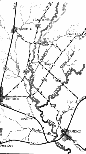
Laneport to US Highway 77
37 Miles
Laneport to US Highway 77
37 miles
This 37-mile section of the San Gabriel River flows through portions of Williamson and Milam Counties. The river along this stretch has been determined to be somewhat different in character than the river section previously described. Along this section, the river flows fairly deep within its flood plain and the view usually is restricted to the riverbed and steep banks. This change in the nature of the river is primarily due to the Balcones Fault which passes across the river at Georgetown. Water levels are such that the San Gabriel along this section is feasible for recreational use most of the time. Water quality is good, and no major hazards are present. An occasional small rapid or area of fast water is found. Access to the waterway is available at numerous roads crossing the river.
A good entry point for use of this section of the San Gabriel River is the county road crossing off FM 1331 in the town of Laneport. Additional waterway features and distance between each are as follows:
FM 486 crossing - 5 miles east of Thorndale.
(7 miles)
County road crossing off FM 486 - 8 miles
northwest of Rockdale. (5 miles)
Alligator Creek - enters on the left. (3 miles)
County road crossing between FM 487 and
FM 908 - 5 miles northwest of
Rockdale. (3 miles)
Brushy Creek - enters on the right.
(4.5 miles)
FM 487 crossing - 5 miles north of Rockdale.
(0.5 mile)
Four miles downstream the San Gabriel
River joins the Little River. Recreational
use can be continued on the Little River
to the US 77 crossing one mile southeast
of Cameron. (14 mile)
San Marcos River
The analysis has found the San Marcos River to be one of the most popular recreational rivers in Texas. The river rises at Aquarena Springs within the city limits of San Marcos, flowing approximately 75 miles through heavily wooded banks to join the Guadalupe River. A wide variety of water types, including a few rapids, many small riffles and an abundance of clear, quiet pools are present. Average width of the stream is 30 feet; however, it narrows between steep banks in its lower reaches. In periods of low water, numerous log jams are found, especially downriver.

San Marcos River
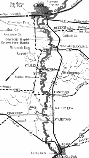
San Marcos to Luling
43 Miles
San Marcos to Luling
43 miles
This 43-mile section of the San Marcos River meanders through portions of Hays, Caldwell, and Guadalupe Counties. The river twists and turns through scenic countryside with many small towns located along the banks. Even in dry periods, this section of the San Marcos River maintains a sufficient flow of water for normal recreational use. The river just below San Marcos is very clear and fish can be seen below the surface.
Three dams are located along this section which, due to their height, prove to be dangerous when floating the river. In addition, there are at least two rapids (see map) along this section which merit careful inspection prior to navigation. Several roads and streets cross the San Marcos River, within the city of San Marcos, and provide access. Waterway features and distance between each are as follows:
San Marcos City Park - a public boat ramp is located at this point.
IH 35 crossing - in San Marcos. (0.5 mile)
Road Crossing - one-half mile east of IH 35 crossing. (0.5 mile)
Blanco River confluence. (2.5 miles)
Cummings Dam - small dam that is dangerous; therefore a portage is required. (1 mile)
County road crossing off SH 80 - 3 miles east of IH 35. (0.5 mile)
Private camp - one-half mile downstream from previous crossing. (0.5 mile)
County road crossing off SH 80 - (3.5 miles)
Private camp - just above Martindale Dam, on the right bank. (0.5 mile)
Martindale Dam - small dam is dangerous;
therefore portage is required. (0.0 mile)
Low Water bridge - directly below Martindale
Dam. (0.5 mile)
FM 1979 crossing - at Martindale, 100 yards
of public shoreline along the road right-of-way. (0.5 mile)
FM 1977 crossing - 1 mile east of Staples,
100 yards of shoreline along the road
right-of-way. (5.5 miles).
Staples Dam - small dam is dangerous;
therefore a portage is required. (0.5 mile)
FM 20 crossing - just west of Fentress,
75 yards of shoreline along the road
right-of-way. (7.5 miles)
Private camp - on county road off SH 80,
1 mile south of Fentress. (0.5 mile)
County road crossing - 1 mile west of Prairie
Lea. (2.5 miles)
County road crossing off SH 80 - 1 mile
north of Stairtown, 30 yards of shoreline
along the road right-of-way. (2 miles)
County road crossing off SH 80 - just east
of Stairtown, 100 yards of shoreline
along the road right-of-way. (1 mile)
US 90 crossing - 100 yards of shoreline
and a roadside park are present on the
road right-of-way. (6 miles)
Luling Dam - just upstream from US 80
crossing. Small dam is dangerous;
therefore a portage is required.
(6.5 miles)
US 80 crossing - just west of Luling.
(0.5 mile)
Luling City Park - just west of Luling.
One-half mile of public shoreline and
camping facilities. (0.5 mile)

San Marcos River
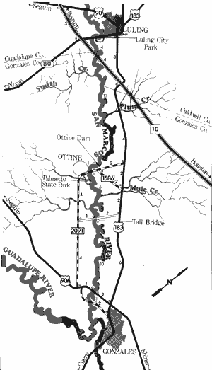
Luling City Park to Gonzales
39 Miles
Luling City Park to Gonzales
39 miles
The San Marcos River flows through portions of Guadalupe, Caldwell, and Gonzales Counties along this 39-mile section. Only in periods of extended drought is there insufficient water to support recreational use. A few swift channels and shallow riffles exist, along with numerous log jams and steep, muddy banks. Lush vegetation plus numerous and varied species of wildlife create one of the more scenic sections of river in Texas. However, numerous log jams may be encountered and portages are often required.
This analysis has found that several points provide access to this section of the San Marcos River, but that steep, muddy banks present problems. A good point of entry is Luling City Park, located adjacent to State Highway 80, just east of the city limits. The park provides about one-half mile of shoreline and camping is permitted. Additional waterway features and distance between each are as follows:
IH 10 crossing - 2 miles south of Luling
(presently under construction). (4 miles)
Smith Creek - enters on the right.
Plum Creek - enters on the left.
Ottine Dam - 1 mile upstream off FM 2091
bridge. (17 miles)
FM 2091 crossing - near the town of Ottine.
Very steep banks at crossing. (1 mile)
Palmetto State Park - adjacent to Ottine,
9 miles northwest of Gonzales. Possible
access at the abandoned low water
crossing in the Park. (0.5 mile)
Mule Creek - enters on the left.
County road crossing off US 183 - 6 miles
northwest of Gonzales. A tall rickety
bridge crosses the river. Banks are
extremely steep and access is fenced
off. (6 miles)
US 90A crossing - 2 miles west of Gonzales.
Extremely steep banks exist. (10 miles)
County road crossing - 2 miles west of
Gonzales. (1 mile)
Two miles downstream the San Marcos
River joins the Guadalupe River.
Top of Page | Table of Contents